Tuesday, March 14, 2017

Gathering Data: Sand Mine Suitability in Trempealeau County

Nathan Sylte
03/14/17


Gathering Data

Introduction:

The objective of this lab was to re-orient with the method of collecting data from internet sources. Also, part of the objective was to import the data into ArcGIS, join the data, and project data from these different sources into one coordinate system. A geodatabase to store the data was also created.

The scenario involved the first of several steps in an ongoing project. The project is to build a suitability and risk model for sand mining in Wisconsin. As discussed in a previous post about sand mining in Wisconsin, sand mining is very controversial. This makes the suitability and risk model of sand mining in Wisconsin very important.


Overall, the objectives can be laid out in the following manner.
1. Download data from different websites.
2. Import the data and join certain tables.
3. Create a python script to project, clip, and load all of the data into the geodatabase that was created.

Methods:

Data for the project first had to be retrieved and downloaded from online sources. The following sources used are numbered below. After the data were downloaded the data were unzipped and then extracted. The data were then loaded into the proper geodatabase.

1. (U.S. Department of Transportation). The first data retrieved was United States rail lines data. This data was located on the U.S DOT web page. USA DOT Website . After reaching the site the polyline feature class was selected to download the railway data.

2. (USGS National Map Viewer). Next, the 2011 National Land Cover Database was used to download land cover data for Trempealeau County, Wisconsin LandCover Data . Elevation data for Trempealeau Country was also retrieved from this site.

3. (USDA NASS Geospatial Data Gateway). The land crop cover data was found on the US Department of Agriculture website USDA CropCover. The Trempealeau County soil data was then navigated to.

4. (USDA NRCS Web Soil Survey). After going to the webpage USDA web soil survey, Trempealeau County was selected as the AOI (area of interest). Then the soils data was simply downloaded.

5. (Trempealeau County Land Records). Trempealeau County data was found on the Trempealeau County website Tremp County Data. The entire Trempealeau County geodatabase was downloaded.

After the data were downloaded py.scripter/python code was used to create three separate output rasters. The output rasters are results from the DEM model, Crop-cover data, and the Land-cover data. Python Code can by found here Python Script.

Results:

A map was created from the three output rasters which shows crop cover, general landcover, and elevation (Figure 1). Trempealeau County is located in a very hilly region. There are many hill or "bluffs" in Trempealeau County which can be clearly seen on the DEM. The landscape was also dominated by deciduous forest mixed with agricultural fields. Accounting for the southern border of the county is the Mississippi River which provides a large amount of wetland habitat.

Figure 1.

Data Accuracy:

The data accuracy was assessed based off of the metadata provided. Certain metadata was difficult to locate such as Planimetric Coordinate Accuracy. Metadata are shown in the table below (Figure 2).
Figure 2. Metadata displayed. Certain metadata proved difficult to locate and is marked as NA.

Conclusion:

There are great amounts of data that are available online. Understanding how to properly download online data is an important skill that should be utilized when completing a project. Furthermore, many online datasets and datasets in general are extremely large. Working with the data can become time consuming. Therefore, utilizing python scripter to perform various processes on the data can save time. Utilizing python becomes more important the larger the dataset gets. Finally, metadata should always be collected from online datasets. This gives indication into the data integrity. If the dataset does not have any metadata associated with it then there is cause for concern.






Python Scripts (Ongoing script)

Nathan Sylte
3/17/14

Python Script 1 for Exercise 5: Sand Mine Suitability in Treampealeau County

Introduction: Utilizing Python Scripts 

The objective for the following exercises is to gain experience utilizing python scripts to perform various tasks in GIS. Becoming acquainted with PyScripter and the coding language required to use PyScripter will be an important skill to have in the geospatial field. Utilizing python is a necessity to save time and increase efficiency which is extremely important when working with large quantities of data.  

Results: Python Script 

Below is the resulting python script from the Gathering Data: Sand Mine Suitability in Trempealeau County lab shown in notepad (Figure 1). 
Figure 1. Python Script 

The beginning of the script sets up the system modules and sets the environmental settings. The location of the three rasters that I was going to project and extract was set as the environment. Next, the rasters were looped into a different (new) folder using the listOfRasters function. The ProjectRaster_managment function was used to project the rasters in the desired coordinate system. Following this, the rasters were extracted to the boundary of the Trempealeau County. Last, the RasterToGeodatabase function was utilized to place the output rasters in the TMP (Trempealeau County) geodatabase. The outputs can be viewed at Sand Mine Suitability


Python Script 2 for Exercise 7: Network Analysis 

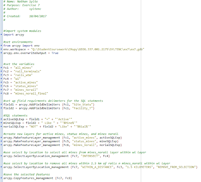
Below is the resulting python script from the network analysis portion of the ongoing sand mine suitability project (Figure 2). 


Figure 2. Python script for Exercise 7: Network Analysis. 


The script begins by setting up the different variables that will be used later on, and primarily consists the feature classes that will be created. Next, an SQL statement was created to query out the features that were to be used. In this case the query selected active mines, separated out facilities with the word mine in the title, and separated out facilities that did not have the word rail in the title. 

After the query statements were generated, three separate layers were created from the query selections. The mines that were within the State of Wisconsin were then selected by using the "intersect" tool. Mines that were not in the State of Wisconsin were then removed. The last part of the script copied the selection so that a new feature class could be generated. In this case the feature class was called mines_norail_final (Fc8). 

Python Script for Exercise 8: Raster Modeling 


Thursday, March 2, 2017

Sand Mining in Western Wisconsin

Nathan Sylte

GIS 2

Sand Mining in Western Wisconsin 

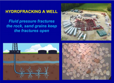
    The mining of "frac" sand in Wisconsin for use in the extraction industry has become an extremely controversial issue throughout the state. Sand mined in Wisconsin is typically used for hydraulic fracturing (fracking) (Figure 2.). Fracking is a technique that is used to extract hydrocarbons such as oil or natural gas that could not otherwise be reached through conventional drilling/extraction methods (Wisconsin DNR).This method for extracting hydrocarbons has been around for 60 years. However, recent advancements in drilling technology have made extracting hydrocarbons with the use of fracking economical in regions where it was previously too costly to extract hydrocarbons. Overall, this post is intended to provide an overview of sand mining in Wisconsin. Several topics will be discussed including the issues and risks associated with sand mining in Wisconsin. An overview of how GIS can be used to investigate sand mining will also be discussed.

    So what is sand mining in western Wisconsin, and why is frac sand mined here? The sand that is used in fracking must meet very specific qualifications. Frac sand must be extremely round and uniform in size (Sand Mining Facts ). The sand must also be pure quartz which makes the sand very hard. The specific strength and size specifications are what allow this type of sand to be used in hydraulic fracturing. Due to these specific specifications frac sand cant be found just anywhere. It just so happens that the correct sand can be found in certain sandstone formations throughout northwest and central Wisconsin. The specific sandstone formations where frac sand can be found includes several Cambrian formations (Wisconsin DNR). These Cambrian formations primarily include the Jordan, Wonewoc, and Mt. Simon Formations (Figure 1). The absolute best sand that can be used in the fracking industry is found in the Jordan formation. The Jordan formation is narrowly found in the southern part of Pierce County and western section of the Chippewa Valley.

    Part of the controversy surrounding frac sand mining includes the methods used to actually mine the sand itself. The procedure involved to mine the sand includes several steps (Wisconsin DNR). First, overburden must be removed to expose the sand. Overburden can describe vegetation and topsoil that are variable in thickness. This step is generally performed by heavy machinery such as scrapers, bulldozers, and excavators. After the sand has been exposed it must then be excavated. Excavation is generally done by large front end loaders and excavators. However, a blasting step is sometimes required to allow the sand to be removed. Blasting involves the use of explosives to loosen the sand for excavation. Blasting has the potential to create dust emissions so steps are taken to reduce those emissions. One of the steps taken to reduce dust emissions involves the use of stemming material, which is used to back fill explosive bore holes.  The last steps involved in the sand mining process involve the crushing and shipping of the sand. Many times the sand must be crushed at the mine site. Crushing is done to further sort the sand into the desired size. After the target sand has been separated the sand is then shipped to a sand processing plant to be processed into frac sand. It is important to include that after the mine is cleared of the desired sand, a reclamation process must occur to restore the area as best as possible. The reclamation process is typically an on going process that is designed to restore topsoil and integrity to the area so that the location can return to as much of a pre-mine state as possible.

    Although steps are taken to mitigate the impact of sand mining. Environmental issues will often arise and can include the following (Wisconsin DNR). The first issue being that of air quality and pollution. Dust and chemicals involved in the handling and processing of the frac sand are often released into the surrounding environment leading to a decrease in air quality. Air quality issues typically arise in the areas around the mine and processing sites themselves.

    Another sand processing activity than can have environmental implications is the washing of the sand at the processing plant (Wisconsin DNR). The process of washing and cleaning the sand involves the use of many thousands of gallons of water. In fact, the washing of the sand can use up to 3,000 gallons of water per minute. It should be added that there are efforts to recycle the water by putting it in holding ponds to be re-used. Despite efforts to re-use as much water as possible, processing plants can have great impacts on the local water tables. A sand processing plant can use up to 2 million gallons of water per day. This has the potential to significantly impact trout streams as well as personal home wells. There have also been many anecdotal references to a sand processing plants ability to severely disrupt local wells and water tables. It should also be added that various chemicals are used during the cleaning process which could have the potential pollute if not properly monitored, contained, and recycled.

    An important impact that frac sand mining can have on the local area has to do with the transportation of the sand. Sand is often transported via dump trucks and semi trucks from the mine site to the processing plant. These heavy vehicles can decrease the longevity of road ways causing millions of dollars in repairs.

    GIS (geographical information systems) software is an important tool involved in the monitoring of sand mining and processing. GIS can be used to monitor environmental impacts and local infrastructure. For example, GIS could be used to monitor regional wells and water table levels around sand processing facilities. The software could also be used to plan trucking routs and monitor the roads the trucks travel on. Databases could be generated in both instances that could be used for analysis purposes. GIS can also be used to map out where the sand mines should go, and provide information on the mines condition. The use of GIS software has the potential to save time and money, as well as increase environmental safety. These factors are ultimately beneficial to the companies and local communities involved in sand mining.

Figure 1. Above is a map of frac sand mines and processing plants throughout the state of Wisconsin A large cluster of sites can be seen in western Chippewa County. This map is provided by the Wisconsin Geological and Natural History Survey. Sand Mining Facts

 
Figure 2. Depicted is the general process of hydraulic fracturing. Also shown is the quartz sand used in the process of fracking. Hydrofracking and Sand Mining


References:

Wisconsin DNR. (2012). Silica Sand Mining in Wisconsin. Retrieved from http://dnr.wi.gov/topic/Mines/documents/SilicaSandMiningFinal.pdf

Wisconsin Geological and Natural History Survey. (2012). Frac sand in Wisconsin. Retrieved from http://wcwrpc.org/frac-sand-factsheet.pdf